Rural Areas - Waitaki District Plan Review

Bridget Irving, Simon Peirce

Attention Rural Landowners in Waitaki  

Changes to the Waitaki District Plan relevant to landowners in rural areas

Bridget Irving, Simon Peirce, Josh Alexander

Introduction

1. On 1 March, the Waitaki District Council notified its Proposed District Plan (PDP), initiating a review of the planning rules for the district. The PDP regulates land use, subdivision and development with potential significant implications for the future of the Waitaki District.

2. Public submissions are open until 9 May 2025. If these changes affect your property or future plans, this is your opportunity to have a say by lodging your submission here!

3. This article focuses on changes to the Rural Zone, the largest zone in the district. It covers key changes that typically impact landowners in rural areas, including default minimum lot size for subdivisions and restrictions on land uses in sensitive ecological or landscape areas.

4. Although this article discusses changes to future activities, it is important to note that existing permitted land uses may continue even after the PDP takes effect, under existing use rights in the Resource Management Act (RMA). However, new activities may require resource consent under the PDP.

Key Changes Affecting Rural Landowners

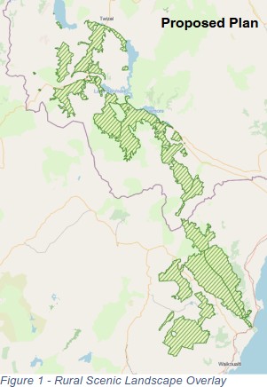
Minimum lot sizes are increasing

5. The PDP proposes to increase the minimum lot size for subdivisions, limiting the amount of land that can be feasibly subdivided. This is achieved through:

Table 1: Minimum Lot Size Comparison (Current v PDP)

6. Currently, rural areas in the Waitaki District are divided into the Rural General Zone and Rural Scenic Zone. The PDP merges these into a single Rural General Zone while converting the Rural Scenic Zone into an overlay. This means the minimum lot size in the new Rural General Zone will increase from 4 ha to 20 ha.

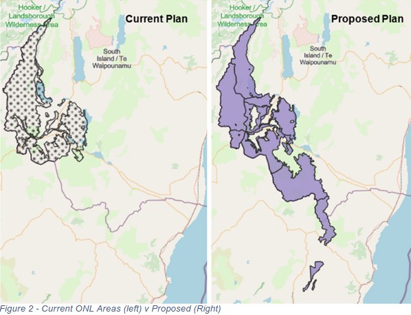
7. The increase is intended to address conflicts between farming operations and newly introduced residential activities (reverse sensitivity issues).

8. This may significantly impact landowners who have historically relied on the ability to subdivide small lifestyle blocks. A report by Macfarlane Rural Business[1] highlights that lifestyle blocks often yield a higher return per hectare compared to primary production. Additionally, land values for properties near the new minimum lot size threshold may be affected.

Tips for submissions:

If you disagree with the size of any minimum lot threshold, make sure to include a reference to SUB-S1 in your submission!

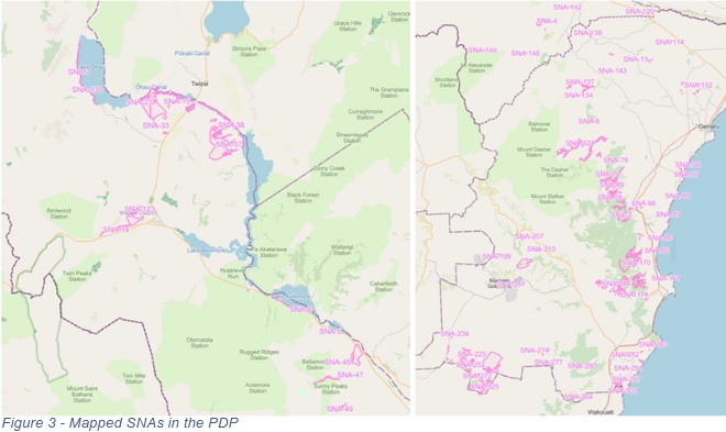
If you disagree with the extent of the zones or overlays, make sure your submission is on ‘a map layer’!

New Overlays = New Restrictions

9. The PDP introduces overlays as an additional layer of regulation. An overlay is a planning tool that imposes specific rules on properties within its boundaries, in addition to zone rules.

10. The most significant overlays affecting rural landowners are:

Rural Scenic Landscape Overlay

11. The RSL Overlay replaces the former Rural Scenic Zone (refer Figure 1).

12. Properties within this overlay will have an increased minimum lot size of 40 hectares per residential unit.

13. The 40 ha threshold is based on Macfarlane Rural Business findings, which suggest this is the minimum area required for long-term sustainability of sheep, beef, deer farming, forestry, or conservation (typically on LUC 6-8 land).

14. Some areas were recommended for a 100 ha minimum, but this has not been included in the notified PDP.

Outstanding Natural Landscape Overlay

15. The PDP does not change the existing 100 ha minimum lot size for ONLs. However, the mapped ONL areas have expanded significantly, meaning more properties will now be subject to these restrictions.

16. Land within an ONL is subject to stricter planning rules aimed at protecting landscapes of national importance. Restrictions include:

17. If you are affected by this expansion, making a submission can help ensure your concerns are considered and ensure that the basis for identifying an area is ONL is sound.

Tips for submissions:

If you would ever consider planting a forestry block on land that is designated as an ONL (see Figure 2) then it is important that you make a submission. Make sure to reference NFL-R14 when making this submission.

Significant Natural Areas

18. Significant Natural Areas (SNAs) are new to the PDP and follow from the requirements of the National Policy Statement on Indigenous Biodiversity 2022 which has the aim of maintaining indigenous biodiversity in New Zealand.

19. SNAs have received a lot of attention over the last few years due to concerns around the restrictions that they might impose on current land uses, particularly primary production. The PDP has now mapped SNAs (as illustrated below) and introduced rules that seek to protect the significant indigenous biodiversity values of these areas.

20. If your land is identified as an SNA, the following restrictions will apply (among others):

21. The Government had initially required SNAs to be implemented by 2027, but this has now been extended to 2030. If you want to influence the timing of these restrictions, lodging a submission is important

Tips for submissions:

If you think the Waitaki District Council is rushing into making rules about SNAs, make sure your submission is on the ECO subchapter generally!

If you disagree with any of the areas mapped as SNAs (see Figure 3), or think other areas should be considered, make sure your submission is on ‘a map layer’!

Submit now, or lose out

22. The PDP is not set in stone. The submission period is one of the few opportunities for landowners to provide feedback and shape the future of the Waitaki District.

23. If affected by an overlay, consider requesting an amendment to boundaries or rules.

24. Our Resource Management specialists are closely monitoring changes to the Waitaki District Plan. If you have concerns or need assistance with a submission, contact us—we are here to help.

[1] Jamie Gordon Section 32 Evaluation Report Rural Zones (Waitaki District Council, March 2025) at 48-94.